

Of the three East African mountains, the Rwenzori languish in a kind of half consciousness, aloof from the main stream trekking routes and rarely visited in comparison to its famous cousins Mt. Kilimanjaro and Mt. Kenya.
Trekking the mystic Rwenzori Mountains National Park in Uganda is a truly fantastic and unique experience, the wonder of the high glaciers, the beauty of the valley of nine lakes, the bearded lichen hanging from giant heathers with a backdrop of rocky cliffs, crags and snow capped peaks. The wide variety of flora and fauna with several biospheres as you ascend through different vegetation zones creates the ultimate experience for trekking. Never before has this unique and beautiful trek been available, totally untouched and undoubtedly one of the most beautiful treks in the world.
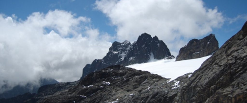
The Rwenzori Mountains is a World Heritage Site and offers the opportunity to see nature at its best. The plant life varies from heavy tropical rainforest, bamboo forests, and montane cloud forests to alpine vegetation and the scenery is truly spectacular. Above 4,500 meters the snow and glaciers add that special dimension to the wondrous views throughout this pristine mountain range. The highest peak, Margherita rises to 5109 meters above sea level with the range stretching some 120km north/south and 48km east/west.
The other peaks are:
- Mt. Stanely/Margherita Peak – 5109m
- Mt. Speak – 4889m
- Mt. Baker – 4843m
- Mt. Gess – 4797m
- Mt. Emin – 4791m
- Mt. Luigi de Savio – 4626m
- Mt. Alexandria and Mt. Albert
The range is only 80 miles long but contains one of the most dramatic diversities of ecosystems in the world, for here within just a few miles from each other are the heat of tropical jungles and the cold of glacial ice. In fact, there are five distinct zones of habitation generating a world of amazing biodiversity.
The range was named Rwenzori by European explorer Henry M. Stanley, after a native word meaning “rain maker.” Indeed, the Rwenzori is a rain maker, for up to 350 days a year rain falls on these mountains, feeding the dense foliage.
At the base is the African SAVANNA teaming with animals including elephants and zebras. This zone is mostly between about 3,000 and 5,500 feet (914 – 1,676 m.).
Above the grasslands is the RAINFOREST from 5,500 to 7,500 feet (1,676 – 2,286 m.). Here are giant ferns, wild banana trees and lianas.
Above the jungle is the great BAMBOO forest, reaching up to around 9,500 feet (2,895 m.). Bamboo, a type of grass, can grow up to three feet a day here, and reach over a hundred feet in only two months! This forest type is one of the most unique habitats to walk through, in my opinion.
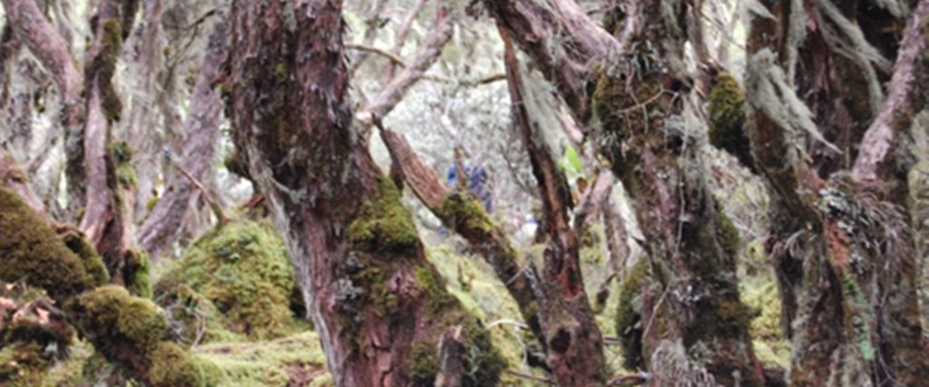
OK, so above the bamboo is the HEATH zone. This zone extends up to around 12,000 feet (3,657 m.) or so, and is a land of dripping lichen-covered heather trees looming over a ground cover of mosses and liverwort. The trees although 40 feet tall or so, are relatives of the low shrub growing in the Scottish moorlands.
Going higher, we reach the ALPINE zone, above 12,000 feet (3,657 m.), a land which in its lower sections is dominated by giants. Here are plants unique only to the Afro-Alpine zone, including the tree groundsel and giant lobelia. The upper reaches of this zone, extending up to around 14,500 feet (4,419 m.), consist mostly of rocky terrain covered with black lichens and brown mosses.
Finally, above 14,500 feet and reaching to Margherita Peak at 16,763 feet (5,109 m.) the highest point in the range, atop Mount Stanley, the Rwenzori Mountains are wrapped in permanent snow and storm-swept glaciers. The first known ascent of the highest peak was made by Luigi di Savoia, the Duke of Abruzzi, accompanied by J. Petigax, C. Ollier and J. Brocherel, in 1906.
How to get there
Currently, the best access to the Rwenzori is from Uganda through Entebbe International airport. There are many hotels available in Entebbe and in Kampala only about half an hour to the north. From Kampala, there are two major routes to the mountain: a northern one through the beautiful town of Fort Portal, then south to Ibanda, and a southern route through Kasese that crosses the equator twice. Each of these takes the better part of a day to reach Ibanda at the foot of the mountains. The roads on the northern route vary from excellent to rough dirt tracks, while those on the southern route are generally good paved surfaces.
What to bring
This list includes medicines, climbing equipment and foods.
Medicines include:
- Malaria prophylaxis
- Diamox (helps acclimatization and reduces risk of edema)
- Non-prescription painkillers (like panadol – avoid aspirin).
- Sleeping pills (hard to sleep at altitude for some)
- Sun Screen
Other Equipment
- Dark sunglasses
- hats for sun/rain
- Warm hat for high altitude climbing
- Mountain jacket
- Rain gear (optional – you’ll get wet no matter what) Fleece jacket
- Fleece vest (if light, a nice addition to the fleece jacket) Sweater
- Long sleeve Trekking shirts (long sleeve)
- T-shirt(s)
- Hiking, climbing pants
- Shorts for walking at lower altitudes light weight long underwear
- Light pair of gloves for camp
- Mountain gloves or mittens/over mitts for climbing the rope
- Crampons
- Climbing harness
- Day pack/climbing pack
- Tent (provided for all our clients)
- Sleeping bag
- Sleeping mat (provided)
- fleece jacket and sweater; T-shirts; hiking/climbing pants; shorts;
- Light weight long underwear
- Comfortable camp shoes or sandals
- Comfortable walking shoes (runners)
- Mountain boots that can fit crampons for going to summit.


